Theory
The 1:15 slope criterion
The Norwegian Water Resources and Energy Directorate (NVE) established in Kvikkleireveileder 1/2019 that a conservative limit for landslide retrogression in quick-clay is a slope of 1:15 (vertical:horizontal).
This means: for every 1 meter of height difference, the landslide can propagate up to 15 meters horizontally.
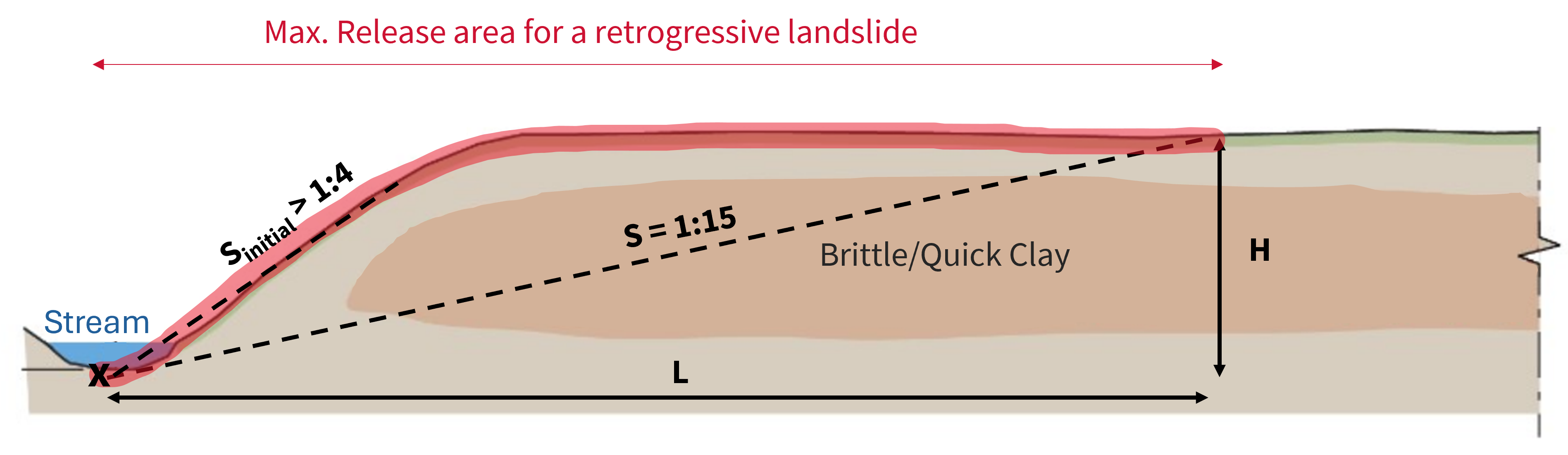
The same conceptual model is also used for the two-phase retrogression workflow: an initial slope around 1:4 can be used to evaluate whether erosion may trigger an initial landslide, followed by retrogressive propagation using the more conservative 1:15 criterion.
Methods
Terrain Criteria
What it does: For each pixel in the DEM, checks if the slope from that pixel back to any source point exceeds 1:15 (or a custom threshold).
How it works:
- Load a DEM (from Høydedata or a local raster)
- For each pixel, compute the slope to the nearest source point
- Classify pixels by slope: 1:20, 1:15, 1:10, 1:5, 1:3
- Polygonize the result into a GeoDataFrame
Best for: Quick overview of potentially affected areas. Fast, memory-efficient.
Limitations: Doesn't model actual propagation — just geometric reach.
Retrogression
What it does: Starting from an initial release area, expands outward step-by-step, only into pixels where the slope criterion is met.
How it works:
- Rasterize the source geometry onto the DEM
- Create a buffer ring around the current release
- For each pixel in the buffer, check if the slope from the source to that pixel exceeds the threshold
- Add qualifying pixels to the release area
- Repeat until no more pixels qualify (or max_length reached)
Best for: Continuous, realistic release area shapes. Honors terrain features that might block propagation.
Variants:
run_retrogression()— Single-phase with one slope thresholdrun_retrogression_with_initial_landslide()— Two phases: first a steep initial failure criterion (e.g. 1:4) to assess whether erosion can trigger an initial slide, then retrogressive propagation with 1:15
Profile Retrogression
What it does: Analyzes retrogression along cross-section profiles perpendicular to a source line.
How it works:
- Generate terrain profiles perpendicular to the source line
- For each profile, find where the 1:15 slope criterion is met
- Connect the retrogression points across profiles
- Build a release area polygon from the connected points
Best for: Detailed analysis along a known escarpment or riverbank. Gives you control over the analysis direction.
Limitations: Requires pre-defined profile lines.
Parameters
All methods share key parameters:
| Parameter | Default | Meaning |
|---|---|---|
min_slope |
1/15 | Slope threshold (steeper = less propagation) |
min_height |
5 m | Minimum height difference to start checking slope |
min_length |
75 m | Unconditional propagation distance before slope check |
mask |
None | GeoDataFrame to clip results (typically MSML) |